Gondwana, then and now : Failure of Academic Scholarship
Defining ancient Gondwana, scholars note that it was a landmass in the ‘south’ that formed about 250 million years ago; scientists say that it broke apart from the super continent of Pangea. Some others say it was formed roughly 510 million years ago and to have lasted until about 150 million years ago.
Scientists’ idea on the geographical landmass of the ‘ancient world’ does not match with maps of ancient geographers at all. Scientists of our times find fault with geographical explanations of Ptolemy, Eratosthenes and Periplus.
Most modern geologists’ and palaeontologists’ idea of the Earth’s rocks is based on locations of fossils, a wrong theory but has gained academic popularity – that the Earth’s land masses have been engaged in a gigantic waltz across the planet. Movement of the Earth’s tectonic plates(do they really exist?) influences the geographical change of the positions of the oceans, mountains and valleys in a continuous manner.
Looking at what the scientists now believe, say, write, and preach :
Modern scientists preach that the supercontinent Pangea began fragmenting around 250 million years ago, producing the Northern landmass known as Laurasia and the Southern landmass Gondwana. Then, the massive landmass of Gondwana began to pull apart around 165 million years ago. This process took a long time. One of the last areas to separate was Tasmania (Australia) from Antarctica around 45 million years ago.
This geographical explanation offered by scientists shows the extent of their ignorance on the ancient world; their propagation of the theory of the formation of Pangea, Gondwana and Laurasia landmass is result of their not reading the ancient literature which are preserved elsewhere other than their own countries.
Mesosaurus or the ‘middle lizard’ which lived in the early Permian 299 to 271 million years ago, became the new reptile to carry forward the search for the lost continent’s geographical existence in Southern Africa and South America. Finding its remains confirmed that Africa and South America must have been connected long ago. Similarly is the case with Lystrosaurus or the “shovel lizard” which lived around 250 million years ago in the early Triassic. Its remains have been found in Antarctica, India, China and South Africa. It was a pig -sized herbivore. The discovery of Lystrosaurus fossils at Coalsack Bluff in the Transantarctic Mountains by Edwin H. Colbert and his team in 1969–70 helped confirm the theory of plate tectonics. Lystrosaurus had already been found in the early Triassic of southern Africa as well as in India.
Glossopteris or ‘tongue’ is a tree , scientists say, dominated the Gondwanan landscape from the beginning of the Permian (@ 300 mya) until their extinction about 50 million years later. The discovery of Glossopteris fossils across most of the Gondwanan land masses helped scientists to understand that the supercontinent Gondwana once existed.
A series of continental collision, scientists believe, helped in the formation of supercontinent Pangea that began in Late Paleozoic and continued into the the early part of Mesozoic. So formation and geographical link between Pangaea, Laurasia, and Gondwana forms the central topic of the academic world that helpe scientists to look at the ancient world.
The part of Pangaea that lies in the Northern Hemisphere is called Laurasia. It includes most of the present-day North America, Greenland, Europe, and Asia.
Gondwana being a part of Pangaea includes most of the present-day South America, Africa, India, Australia, and Antarctica describes the southern hemisphere.
Pangaea’s split into Laurasia and Gondwana began in the Late Triassic, believers of this theory preach.
Gondwana itself began to break up in the mid to late Jurassic period about 150 million years ago. The Gondwana region of India means ‘Land of the Gondas.’. Gondwana sedimentary sequences (Permian-Triassic) are described from the India section. In 1872, Medlicott of the Geological Survey of India (de Wit et al. 1999, Medlicott 1879) suggested this name; and Austrian geologist Eduard Suess and later German scientist Alfred Wegener, advanced this concept.
East Gondwana comprising Antarctica-Madagascar-India-Australia, began to separate from Africa during the Middle Jurassic(about 167 million years ago). In the early Cretaceous period, South America began to drift slowly westward from Africa as the South Atlantic Ocean opened, beginning about 130 million years ago. East Gondwana itself began to be dismembered as India began to move northward, in the Early Cretaceous (about 120 million years ago). India was further broken into the Madagascar block and a narrow remnant microcontinent presently occupied by the Seychelles islands; The India-Madagascar-Seychelles separations appear to coincide with the eruption of the Deccan basalts; Australia began to separate from Antarctica perhaps as long ago as 80 million years (Late Cretaceous), Period. New Zealand probably separated from Antarctica between 130 and 85 million years ago. The continent of Australia-New Guinea began to gradually separate and move north (55 million years ago), rotating about its axis to begin with, and thus retaining some connection with the remainder of Gondwana for about 10 million years. About 45 million years ago, the India Plate collided with Asia, buckling the crust and forming the Himalayas.
The Red Sea and East African Rift are modern expressions of the continuing dismemberment of Gondwana.
In Vol.1 publication of Research Institute for Language and Culture of Asia and Africa, Tokyo University of Foreign Studies, an article of Prof Michael Witzel : ‘Out of Africa: The Journey of the Oldest Tales of Humankind’ (July 2006) needs special attention. Prof Witzel of Harvard University, is a prolific writer, and a scholar and enjoys respect from the academic world crossing across nations. There are eleven eminent Professors in the Board of this Project and Prof Witzel is one of them. His article makes special mention on comparative study of mythologies, linguistics and genetics of Laurasian and Gondwana tribes which they call ‘generalised science’.
This type of article from a most respected and learned professor is filled with hypothetical elements on world mythologies and culture with biased individualised opinion.
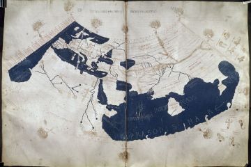
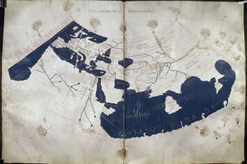
He refers to a particular map for the Gondwana mythologies(given below) :
This is one of the maps of Ptolemy; and is a regional map only. The geography of this map should be seen through the peripheral map of the ‘inhabited world’. But unfortunately, this map has been stretched to include India, Australia and other areas. How many scholars are engaged for years to study the genetic side of the migrants of the so called Gondwana tribe can be seen from this map alone. How scholars are pushing their theories unnecessarily because they have resources is something which ordinarily cannot be imagined. Since more than a decade they are working on a wrong thing. I wrote two Emails giving some hints on the points where Prof Witzel went wrong. Why they will listen me, after all?
History of King Gondophares is attached to Gondwna which connects the Sakas, the Scythians and the Parthians and other ancient tribes with its history; Gondophares was also ruling from Kapil(not Cabul), the land central to the history of human civilization.
Mt Gandhamardan of the Ramayana and the Gundivana of the Mahabharata describe this land of Gondas who call themselves Koitur or Koi. Mt Gandhamardana was very close to the Rama’s Bridge, or the Setu Bandha on the sea.
Pingea, Laurasi and Gondwana stand for names of three villages only; Pali texts very nicely mention these names; but this language is far away from the reach of our scientists as well as from other scholars. Vessantara Jataka gives an idea of the geographical position of Mt Gandhamardana; it is a coined name for Gonda and Mardan, name of two adjoining places identifying this mountain touching their boundaries. Mardan is same as Marda, or Madda country whose biblical name is Median again same as Midian.
According to Strabo, the country of the Gandarai, which he calls Gandaritis, lay between the Khoaspes and the Indus, and along the River Kophes; and here it is also identified with Kaspapyros, a Gandaric city. Herodotus mentions(Book III) the Gandarioi who were under the 7th Satrapy of Darius.
The whole problem before the academic scholarship is that it does not know that ancient India is not represented by the present political India; and today’s Himalaya does not represent its ancient counterpart. Himalaya is the Greek name for Mt Meru, or Mt Sumeru. And Ptolemy’s peripheral map for the ‘inhabited world’ or the Map of Jambudvipa represents the ‘first-land’ of the human civilization.


 © All rights reserved, 2022, Akhil Kumar Sahoo. Design :